 This excavation shows about 400mm of top soil then the ever present friable red-brown loamy clay with minor pebbles.
 As far as i know this red brown deposit covers this whole area sometimes very thick, what i am begining to understand is this deposit is so close to the surface in places it makes the ground around here glow red as the sun lowers and the ground is wet.
The diagram above shows what i now know to be the true superficial geology both to the north and south of the Cleveland dyke in the south west area of Cleveland north east England
Maltby beck deposits
These deposits excavated at Maltby beck are a mirror of the deposits excavated about a mile north east at Stainton beck, the gravel bed is exposed and sits above the red plastic clay as at stainton.
 Ive now cleared the gravel bed, and have noticed it is interrupted by a stoneless deposit, it can be seen to the right of the spade handle.
 There is the same intrusion by the same type of deposit in the gravel bed a km east at Stainton beck.
 This image does not exaggerate the colours if anything it dose not do them justice.
 This is a close up of the deposit that intrudes the gravel bed, there is another separate blue layer above then the dry hard packed friable red brown loamy clay that lays above everything in this area.
 Close up of the gravel bed with the dark red clay below, i now am sure this gravel bed is part of what i have now named the Stainton gravel beds.
 Close up of the intruding deposit.
 The intruding deposit can be seen to the right of the spade handle.
 The lower thin clay layers look like there painted with gloss, the image really doesn't do them justice.


These very good pics were taken by Andy cooper a geologist from tvriggs who has helped me a lot along with Alan, the two lads visited the Stainton main excavation site with me, and although i had doubts about the group early doors i was totally won over by there professionalism and friendly approach, i am totally gob smacked about the level of Andy's commitment to discovering more about the geology of this area, the man deserves a medal!


 I found these rib pieces today in my main excavation at Stainton beck, the end of one of the ribs can be seen just below the end of the tool. Other parts of the two ribs fell away as i removed the clay, they can be seen in the top right of the image.
 The image above shows one rib above the other in the centre.

 This image shows the sequence of seperate consolodated layers that ime investigating at my main excavation at Stainton beck.


 The image shows almost all of the fossils i have excavated from my latest site at Stainton, some bone pieces are not shown as they are being viewed by professionals trying to help me, there are also some larger boulders and slabs still on site that are like the slabs in this image full of marine fossils, of Jurassic and Carboniferous origins.
 Al of the items have one thing in common they have only ever been washed and dried, yet shine like they have been polished.
 I am certain i have have again found the same sequence of individual layers, as at Stainton and several other locations in the south west area of Cleveland north east England.
The image above shows from the bottom up ( a, The ever present red clay) (b, The as yet hidden gravel bed ) ( c, The tell tale white grey colouration that always accompanies the stoneless alluvial layer that sits above the gravel bed, in all locations. )
 The image above and below shows the tool marking were the gravel bed sits above the red and blue clay, the stoneless sandy clay layer can also be seen above the gravel bed in the image above.


 The last image shows the tool marking the point the packed gravel bed below the stoneless blue grey deposit.
This statement as it is titled is only an initial report, and both me and Andy have learnt a lot since it was wrote, but Ive posted it to record Andy as being the first along with Allen to actually get there hands dirty in trying to help me in my work


 This is my latest fossil bone find excavated from the gravel beds in the Sainton area.

 As yet unidentified but i am sure its not bovine.
 Note the ever present shine to these bones dug from the Stainton gravel beds.
Agar 1954 on the deposits in the south west area of Cleveland.
Agar covered in detail the deposits to the north of Stainton created by the ice-dammed water-body that is said to have stood far below the 50 metre elevation of the Stainton site's. Neither of the papers i have now looked at explicitly cover the south west area of Cleveland, but Agar ( 1954) maps the area as being till- covered with no detail on other beds in the area.
 I can now with some confidence state that Agar mapped the area wrong, the area is far from a till covered glacial mess in fact i am yet to come across anything that resembles a till deposit or indeed any glacial erratics on the surface, every area i have excavated is proof in itself that Agar mapped the area wrong, and in doing so tells me he never actually looked hard enough to have the right to map it at all .

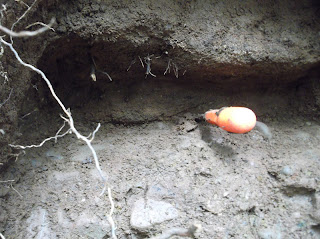
Maltby beck deposits
These deposits excavated at Maltby beck are a mirror of the deposits excavated about a mile north east at Stainton beck, the gravel bed is exposed and sits above the red plastic clay as at stainton.
 Ive now cleared the gravel bed, and have noticed it is interrupted by a stoneless deposit, it can be seen to the right of the spade handle.
 There is the same intrusion by the same type of deposit in the gravel bed a km east at Stainton beck.
 This image does not exaggerate the colours if anything it dose not do them justice.
 This is a close up of the deposit that intrudes the gravel bed, there is another separate blue layer above then the dry hard packed friable red brown loamy clay that lays above everything in this area.
 Close up of the gravel bed with the dark red clay below, i now am sure this gravel bed is part of what i have now named the Stainton gravel beds.
 Close up of the intruding deposit.
 The intruding deposit can be seen to the right of the spade handle.
 The lower thin clay layers look like there painted with gloss, the image really doesn't do them justice.
Sunday, 27 May 2012
Locations of excavations of the stainton gravel beds - Google Maps http://goo.gl/maps/fBft6
Stainton gravel beds, and clay deposits.
These very good pics were taken by Andy cooper a geologist from tvriggs who has helped me a lot along with Alan, the two lads visited the Stainton main excavation site with me, and although i had doubts about the group early doors i was totally won over by there professionalism and friendly approach, i am totally gob smacked about the level of Andy's commitment to discovering more about the geology of this area, the man deserves a medal!

 |
preserved organic layer underneath the Stainton gravel beds.
|
I have recently collected and sieved a sample of the organic material pictured below and found a lot of what look to be hazelnuts and other unknown seeds, the hazelnuts are intact yet hollow.
 |
Close up of a section of the Stainton gravel beds, with organic material between the two fine gravel layers, for some as yet unknown reason at least a third of these smaller gravels are highly magnetic, i am going to collect samples from deeper into the gravels for the tvrigs group to make a deeper petrographic analysis of the magnetic meterial.
|

 |
One layer below my tea cup, and probably at least another two above the Stainton gravel beds pictured above.
|
 |
| Close up of two separate layers |
Bone excavated from deposit above the Stainton gravel beds.
 I found these rib pieces today in my main excavation at Stainton beck, the end of one of the ribs can be seen just below the end of the tool. Other parts of the two ribs fell away as i removed the clay, they can be seen in the top right of the image.
The image below shows the packed sandy clay layer just above the Stainton gravel bed, before i started digging.

Note how tightly packed and previously undisturbed the clay around the bones are.

 The image above shows one rib above the other in the centre.
 This image shows the sequence of seperate consolodated layers that ime investigating at my main excavation at Stainton beck.
The Stainton gravel beds are very rich in fossils and minerals of all ages nearly all in very good condition These Jurassic slabs containing mainly Gryphaea were excavated from the gravel beds at the Stainton village location.
The esk valley

I found this image recently and it shows the ice dammed lake to the north covering most of what is now industrial teeside, then to the south east the esk valley as it was in the late devensian early Holocene?
Then further south the large expanse of lake Pickering, i believe that the water that was held up in what is now the esk valley was responsible for the creation of the deposits ime now excavating in the south west area of Cleveland north east England.
But i personally believe that the release of water and resulting sediments were not created overnight in one big flood instead, i believe it was a period of huge flash flooding with drier interludes that created what i now show in my excavations.
Contents of a 3 metre square x 300mm thick section of excavated gravel bed.
 The image shows almost all of the fossils i have excavated from my latest site at Stainton, some bone pieces are not shown as they are being viewed by professionals trying to help me, there are also some larger boulders and slabs still on site that are like the slabs in this image full of marine fossils, of Jurassic and Carboniferous origins.
Minerals and mineralized bone content of a 3 metre x 300mm section of the Stainton gravel beds
The images below shows minerals and fossil pieces found at my main excavation of the Stainton gravel beds, as i have explained in earlier posts i have also found large very well preserved Jurassic, Carboniferous, and possibly Triassic, slabs in the same 3 metre x 300mm section of excavated gravel bed.
 Al of the items have one thing in common they have only ever been washed and dried, yet shine like they have been polished.
Gravel beds found 3 miles north east.

The image above shows from the bottom up ( a, The ever present red clay) (b, The as yet hidden gravel bed ) ( c, The tell tale white grey colouration that always accompanies the stoneless alluvial layer that sits above the gravel bed, in all locations. )


The image below shows the very dry friable red-brown loamy clay with minor pebbles, that covers every location i have excavated. As i have stated before i am certain most if not all the stone to be found on the land surface of the area i have so far excavated in the south west area of Cleveland will of originated from the washed out gravel beds and moved by man.


Saturday, 20 August 2011
Initial report from Andy cooper tvriggs
Message Body
Dear Mr Barnes,
Thanks for allowing my colleague Alan Simkins and I to visit the excavation work you have undertaken into the deposits alongside Stainton Beck upstream of the former quarry in the Cleveland Dyke. We found them very interesting.
First I would like to say that you are one-in-a-million, very few people have any interest in such things. The fact that you do have an interest, added to the fact that you've done something about it with very little outside help, is to be commended and we hope that you continue this work.
My first impressions of what I saw, when you kindly showed us around on Friday, tell me that the deposits in which the excavations are taking place are quite complex successions of clays, sands and gravels deposited both during, and after, wastage of the last (Devensian) ice sheet which (as we discussed) occupied the Lower Tees Valley around 20,000 years before present.
As you're already aware, during ice-sheet wastage locally a number of ice-dammed meltwater lakes occurred at different heights above sea level. One such water body occurred around the edge of an ice lobe extending up the Tees Valley leaving clay deposits where Normanby Brick Works used to stand on the north western flank of Eston Hills at approx 100 metres above sea level. As the lobe of ice filling the Lower Tees Valley continued to waste away, further water bodies formed at lower levels (the land around Stainton stands approx 30-40 metres above sea level) some of the lakes being quite large. Around South Bank can be found thick deposits of laminated clay belonging to quite a large water body, the thickness of the lacustrine clay seen at Stainton would seem to suggest that it was deposited within either a relatively small water body, or close to the edge of a larger lake. In order to solve this puzzle the deposit needs to be traced away from the beck to determine its lateral extent - a job best done with an auger.
As I have mentioned in my previous e-mail, some of the fossils which you've recovered from the gravels were a little puzzling at first. They include a number of ammonites and bivalves from rocks of Jurassic age and, as Stainton stands on rocks laid down prioir to this (during Triassic times), their origins weren't immediately apparent. My first thoughts were, "How did these fossils get here when the direction of Cheviot ice-movement (from the north and east) carried the glacier across much older rocks?"
During our visit, however, we spoke about two ice streams meeting in the lower Tees Valley. One from Scotland (Cheviot Ice) and another from the Lake District which crossed the Pennies via the Stainmore Gap (Stainmore Ice). Each contains its own individual suite of rock fragments picked up en-route. Within the gravels I saw rocks from both Cheviot and Stainmore streams. I think that the Jurassic fossils originated from the Stainmore Ice which approached Teesside from the north-west. It would have encountered beds of Jurassic age both on the valley floor and moorland escarpment to the south west of Stainton. The high ground of the moors caused this ice stream to split with one part going along the Vale of York, and the other forced eastwards toward the sea. I would appear that this ice picked up the Jurassic specimens
When this easterly lobe eventually wasted, meltwater would carry sand and gravel northward onto the valley floor where low level lakes formed.
On the subject of the Bones:
The great number of bones which you have diligently recovered are really outside my experience, however the fact that they (and some of the fossil specimens) are extremely clean (polished almost) when found is something I can help with. It is probably due to phosphatisation. This is a chemical process occurring during burial within the presence of phosphate-rich ground water. At the moment I have no idea of possible sources for the phosphate. The bone's presence however tends to indicate that the deposit is of Holocene age.
On the subject of the Organic Material:
The layers of organic material could only have originated during the Holocene (after the wastage of Devensian Ice) as flora and fauna recolonised the area. I have been trying to find someone to look at what you've recovered from these layers, so far without success. I do know that Tees Archaeology have done studies on similar beds at Seaton Carew (Hartlepool Submerged Forest) and can only suggest that you read the documentation relating to it which may hold some clues for you and should be available at your local library.
Well, that's about it for now. I'm sorry that we couldn't be of further help to you during the visit, but deposits such as these require careful analysis not able to be achieved in the field. In fact much of it is specialised. I'm sure that pollen analysis of the organic layers will be able to date the deposit much more accurately, but TVRIGS do not (yet) have the means to carry out such tests. Though we hope to be able to perform limited analyses in the future. Being a volunteer group, we rely on the dedication of our members and do not yet have anyone to look at this fascinating area.
Please keep me informed of your progress, especially with regard to having the organic material analysed. I too shall keep trying to get someone to have a look at both the bones and the organic material for you. Pester-power may eventually pay off.
In the meantime, TV RIGS Group will shortly take delivery of a new auger which (with your permission) we'd like to test in the area around your sites with you present of course. This may help you find the lateral extent of the water body responsible for the lacustrine clays amongst other things.
I hope that this e-mail goes a little way toward helping you for now, and will bring your case up with the group at our next meeting with regard to helping you further.
Keep in touch.
With best regards,
Andy.
This statement as it is titled is only an initial report, and both me and Andy have learnt a lot since it was wrote, but Ive posted it to record Andy as being the first along with Allen to actually get there hands dirty in trying to help me in my work
Excavations.
This post is to reassure any groups or individuals who come across my blog that there is no lasting damage to the becks and no wildlife is ever disturbed. If there are signs of life ie Voles or even rats the area gets left alone.
As for the becks themselves any excavations are out of sight, and done in such a manor that the natural flooding of the beck will restore any area back as it was, in the main i choose areas that have recently collapsed naturally therefore not changing the natural course of the becks.
One thing i have noticed that may be of interest to people involved with the wildlife of the becks is wherever i see these ancient deposits exposed, ie the river gravels clays some laminated some not, Voles and other small mammals have had no interest in digging into now or in the past, the material is probably to tough to get through.
Create a Link
Carved bone from Stainton gravel beds.

This carved bone was found in the beck at Stainton just down stream from the main excavation, its been viewed by Tees Archaeology on several occasions over the last 4 years and at 2 universities and by professionals at museum's.
But still i have been given no firm answer on what it was used for and when and who might of made it. I personally find it hard to believe it is just coincidence that it was found less than 10 metres down stream from where i am now excavating bone, including Human preserved in the same manor, buried deep into previously undisturbed ancient river gravels buried under 2 separate alluvial deposits deposits.
Tees Archaeology have visited the dig site and observed the packed gravels were the preserved bone and organic material is being found, but still seem to have no intention to take things further. I find this hard to believe considering the information that could be gained about a period of this areas ancient past 10 to 20.000 years b.p.
Tees Archaeology had there funding stopped by Middlesbrough council in 2012 so are now unable to work in the area .
Tees Archaeology had there funding stopped by Middlesbrough council in 2012 so are now unable to work in the area .


New bones found in Stainton gravel beds.
 This is my latest fossil bone find excavated from the gravel beds in the Sainton area.
Its the lower front section of a mammal jaw, as yet unknown.

I believe the bone may well have been carved like other items found close by.


This piece found close by is the joint that the atlas vertebrae fits to at the rear of the skull.
 As yet unidentified but i am sure its not bovine.
Gravel beds uncovered again at Stainton
 1 This deposit was uncovered about 100 metres north west of my main excavation at Stainton beck , the red outline shows the gravel bed .
 2 The red outline marks the exposed gravel bed , as with most of the other gravel bed sections excavated both at Stainton and elsewhere the average depth is 300 mm , and the deposit is very level .
 3 Hopefully this image shows how tightly packed the Stainton gravel beds are .
 4 The yellow outline shows the usual grey organic layer nearly always found just above the gravel beds .
 1 This deposit was uncovered about 100 metres north west of my main excavation at Stainton beck , the red outline shows the gravel bed .
 2 The red outline marks the exposed gravel bed , as with most of the other gravel bed sections excavated both at Stainton and elsewhere the average depth is 300 mm , and the deposit is very level .
  3 Hopefully this image shows how tightly packed the Stainton gravel beds are .
 4 The yellow outline shows the usual grey organic layer nearly always found just above the gravel beds .