Dear Mr Barnes,
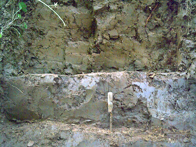
Thanks for allowing my colleague Alan Simkins and I to visit the excavation work you have undertaken into the deposits alongside Stainton Beck upstream of the former quarry in the Cleveland Dyke. We found them very interesting.
First I would like to say that you are one-in-a-million, very few people have any interest in such things. The fact that you do have an interest, added to the fact that you've done something about it with very little outside help, is to be commended and we hope that you continue this work.
My first impressions of what I saw, when you kindly showed us around on Friday, tell me that the deposits in which the excavations are taking place are quite complex successions of clays, sands and gravels deposited both during, and after, wastage of the last (Devensian) ice sheet which (as we discussed) occupied the Lower Tees Valley around 20,000 years before present.
As you're already aware, during ice-sheet wastage locally a number of ice-dammed meltwater lakes occurred at different heights above sea level. One such water body occurred around the edge of an ice lobe extending up the Tees Valley leaving clay deposits where Normanby Brick Works used to stand on the north western flank of Eston Hills at approx 100 metres above sea level. As the lobe of ice filling the Lower Tees Valley continued to waste away, further water bodies formed at lower levels (the land around Stainton stands approx 30-40 metres above sea level) some of the lakes being quite large. Around South Bank can be found thick deposits of laminated clay belonging to quite a large water body, the thickness of the lacustrine clay seen at Stainton would seem to suggest that it was deposited within either a relatively small water body, or close to the edge of a larger lake. In order to solve this puzzle the deposit needs to be traced away from the beck to determine its lateral extent - a job best done with an auger.
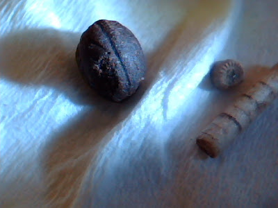
As I have mentioned in my previous e-mail, some of the fossils which you've recovered from the gravels were a little puzzling at first. They include a number of ammonites and bivalves from rocks of Jurassic age and, as Stainton stands on rocks laid down prioir to this (during Triassic times), their origins weren't immediately apparent. My first thoughts were, "How did these fossils get here when the direction of Cheviot ice-movement (from the north and east) carried the glacier across much older rocks?"
During our visit, however, we spoke about two ice streams meeting in the lower Tees Valley. One from Scotland (Cheviot Ice) and another from the Lake District which crossed the Pennies via the Stainmore Gap (Stainmore Ice). Each contains its own individual suite of rock fragments picked up en-route. Within the gravels I saw rocks from both Cheviot and Stainmore streams. I think that the Jurassic fossils originated from the Stainmore Ice which approached Teesside from the north-west. It would have encountered beds of Jurassic age both on the valley floor and moorland escarpment to the south west of Stainton. The high ground of the moors caused this ice stream to split with one part going along the Vale of York, and the other forced eastwards toward the sea. I would appear that this ice picked up the Jurassic specimens
When this easterly lobe eventually wasted, meltwater would carry sand and gravel northward onto the valley floor where low level lakes formed.
On the subject of the Bones:
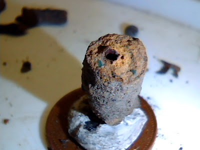
The great number of bones which you have diligently recovered are really outside my experience, however the fact that they (and some of the fossil specimens) are extremely clean (polished almost) when found is something I can help with. It is probably due to phosphatisation. This is a chemical process occurring during burial within the presence of phosphate-rich ground water. At the moment I have no idea of possible sources for the phosphate. The bone's presence however tends to indicate that the deposit is of Holocene age.
On the subject of the Organic Material:
The layers of organic material could only have originated during the Holocene (after the wastage of Devensian Ice) as flora and fauna recolonised the area. I have been trying to find someone to look at what you've recovered from these layers, so far without success. I do know that Tees Archaeology have done studies on similar beds at Seaton Carew (Hartlepool Submerged Forest) and can only suggest that you read the documentation relating to it which may hold some clues for you and should be available at your local library.
Well, that's about it for now. I'm sorry that we couldn't be of further help to you during the visit, but deposits such as these require careful analysis not able to be achieved in the field. In fact much of it is specialised. I'm sure that pollen analysis of the organic layers will be able to date the deposit much more accurately, but TVRIGS do not (yet) have the means to carry out such tests. Though we hope to be able to perform limited analyses in the future. Being a volunteer group, we rely on the dedication of our members and do not yet have anyone to look at this fascinating area.
Please keep me informed of your progress, especially with regard to having the organic material analysed. I too shall keep trying to get someone to have a look at both the bones and the organic material for you. Pester-power may eventually pay off.
In the meantime, TVRIGS Group will shortly take delivery of a new auger which (with your permission) we'd like to test in the area around your sites with you present of course. This may help you find the lateral extent of the water body responsible for the lacustrine clays amongst other things.
I hope that this e-mail goes a little way toward helping you for now, and will bring your case up with the group at our next meeting with regard to helping you further.
Keep in touch.
With best regards,
Andy.


